Ontario Highway 129 links Hwy 17, at Thessalon on Lake Huron’s North Shore, with Hwy 101 just south of Chapleau. The top and bottom quarter of this isolated 200-ish km road is not overly scenic but in between is a wonder of twists & turns, rivers & lakes, rocks & trees, including this awesome spot just a few minutes hike from the road.
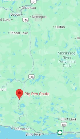
- WHEREABOUTS: Just off Hwy 129, about 2hrs south of Chapleau, and 45 min north of Thessalon or Iron Bridge
- SPECIFIC LOCATION: large gravel turnaround area on west side of road (chute coords N46.650642 W83.414048)
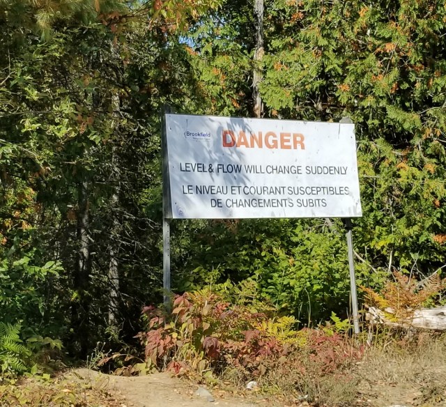
- AMENITIES: none (not an official or maintained public area)
- FEATURES: water access, large open area on river bedrock, scenic views
I first discovered Pig Pen Chute in autumn 2022, on the homeward-bound portion of my first big teardrop camper road trip to Lake Superior’s east coast. I had decided to head inland at Wawa to avoid poor weather affecting coastal regions, which took me to Chapleau, then onward to the hidden gem that is Wakami Lake Provincial Park for a few days, and subsequently south on Hwy 129 to rejoin Hwy 17.
While I came across this scenic spot by chance, turns out it is well-known locally, mentioned on several Algoma country travel web sites, and even has its own Google map pin (for better or worse). Honestly, I just pulled in at a large gravelled area on the roadside which looks like it is used for truck and/or snow plow turning to have a quick pee stop but then ended up spending a couple hours!
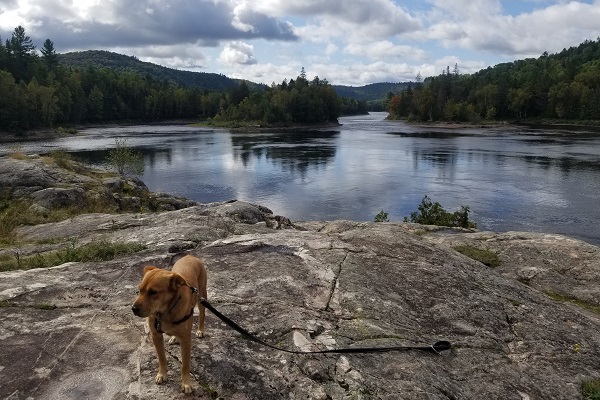
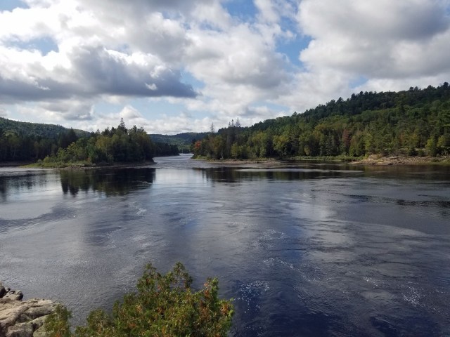
I noticed a well-travelled path, followed it out of curiosity, and a few minutes later emerged from the forest onto a large rock outcrop along the Mississagi River. The views to the south were panoramic, with grand scenery that displayed elements of both Algoma and Canadian Shield landscape. To the north of my viewpoint was the chute itself, a dramatic narrowing of the river which manifested itself in fast-running cascades when I was there in fall, but in spring must be a teeming and wickedly formidable run of rapids.

Rest-stop, picnic or daytrip destination
A short scramble down from the outcrop was easy access to the water’s edge, gentle and away from the main river flow, for my pup Luna to get a drink. On visits to Pig Pen Chute in subsequent years, I saw people swimming down there.
Pig Pen Chute could be a 10-minute diversion from driving, a lunch picnic stop, a couple hours fun & rest along the way, or a destination in and of itself. A brief and easy hike takes you to a spot which is well-removed from the road, beautiful scenery all around, and the sounds are nothing but nature… water rushing, ravens croaking overhead… maybe even a majestic Bald Eagle… you immediately feel like you’re out in the middle of nowhere. Which, in fact, you are—it’s just that it’s so quick to access by car from the road.


The Long and Winding Road

Speaking of the road, having now travelled all or part of it three autumns in a row now, it has surely become a favourite. Hwy 129 sort-of feels like the less-popular cousin to the well-known Hwy 17 which also runs north-south a few hundred km to the west along the stunning shore of Lake Superior. But Hwy 129 has no shortage of stunning scenery itself, showcasing quintessential sights of Ontario’s north with the bonus of being far more lightly travelled. The road also passes over the Atlantic-Arctic watershed between Hwy 101 and 667 (see blog post Roadside Attraction: At a Watershed)
Wikpedia notes this road is one of the most isolated and among the least used of the King’s Highways (the official term for the highways in Ontario, excepting those numbered in the 500- and 600- which are “secondary” highways) and that 129 was the last King’s Highway to be fully paved; the section immediately south of Aubrey Falls remained a gravel road as late as 1982.
(As an aside, it was on the previous year’s big teardrop roadtrip that I travelled Hwy 556, aka Ranger Lake Road, from Hwy 17 north of The Sault to its junction with Hwy 129 north of Pig Pen Chute, when I learned that a provincial “highway” could be a gravel road! Damn good thing I got the option for diamond-plate aluminum on the underside of the trailer. Though the Teardrop’s license plate, in the stream of kick-up from the left trailer tire, is peppered with gravel impact as a reminder of my travels that day.)


Be warned that cell coverage is generally nonexistent along 129 between Hwy 667 & 554, which is to say most of the way, and don’t count on a fuel stop either. But that’s part of the charm: you feel disconnected, “out there”, and deeply immersed in Ontario’s wilderness. The terrain and scenery is awesome through much of the route but do pay attention for logging trucks which, though only occasional, seem to race through the road’s many curves with frightening speed.

Thank You for your article on Pig Pen Chute. I have fished there many times and although I didn’t catch many, just being on the Mississagi and taking in the peacefulness of it all was reward enough.
LikeLike